Draft Smithfield comprehensive plan presented
Published 5:21 pm Tuesday, January 18, 2022
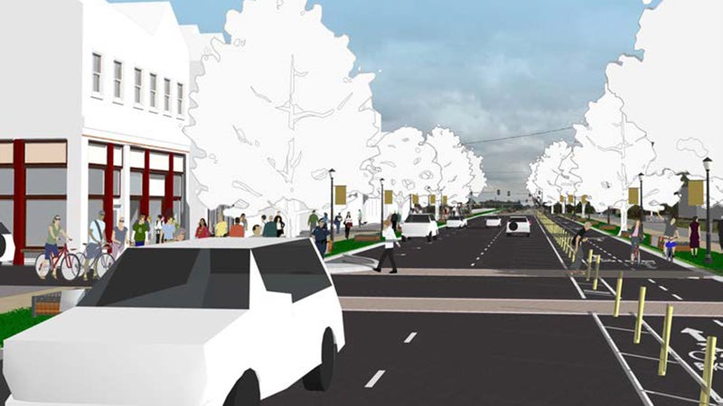
- This drawing, included in Smithfield’s draft comprehensive plan, shows a reimagined, more walkable South Church Street.
Creating a more walkable South Church Street east of the Pagan River and reducing traffic throughout town are among the top priorities listed in a Jan. 11 draft of Smithfield’s new comprehensive plan.
The town’s Planning Commission has been working with Summit Design and Engineering since last spring to create the document, which will guide land use decisions for years to come.
Per state law, a locality’s comprehensive plan must be revisited at least once every five years “to determine whether it is advisable to amend the plan.” Smithfield’s hasn’t seen major changes since 2009.
“Small Town Charm” is the most consistently mentioned reason Smithfield is loved by its visitors or residents, the plan states, but commercial areas outside its historic downtown “have created an atmosphere that does not contribute to this feeling.” It’s “particularly inhospitable for pedestrian and bicycle access, although the town’s grocery stores are there.”
The plan then shows sketches of a reimagined South Church Street with bike lanes, brick crosswalks and walkable storefronts.
“By simply constraining growth, land values may increase and force higher rents on local businesses,” the plan states. “By leaving the current scenario without intervention, the town may see continued growth that detracts from its sociability, walkability, or local businesses by increasing vehicular traffic. However, by encouraging new development and redevelopment that borrows from the scale, form, and design qualities of the historic downtown district, new diversity of uses can be achieved.”
The plan further calls for “reprioritizing” transportation improvements “away from simply widening roads,” and “increasing the amount of opportunities within the local economy, but aligning them with walkability and redevelopment rather than encouraging new sprawl development at the edges of Town.”
The plan includes a future land use map that shows the areas of town along the South Church Street and West Main Street corridors, the Riverside Healthy Living Community on John Rolfe Drive and the former 1730s Pierceville farm and Little’s Supermarket shaded in dark red as “new downtown mixed-use” districts.
“Infill redevelopment should feature minimal to no setbacks,” the plan states. “Buildings should be designed with limited parking and access provided to the rear, with primary access from pedestrians and bicyclists to their front.”
The plan further calls for more affordable and multi-family housing, alleging a racial disparity in Smithfield’s current housing market. According to the document, 17% of Smithfield’s residents live below the poverty line, compared to 9.9% statewide and 12.3% nationwide.
Across the United States, “Black residents are more likely to fall below the poverty line,” and “that trend is more prevalent in Smithfield,” the document states. In the town, 9.2% of white residents and 31% of Black residents fall below the poverty line, compared to 10.3% of white residents and 21.2% of Black residents living in poverty nationwide.
A copy of the draft comprehensive plan can be viewed at smithfieldvacomprehensiveplan.com.
To move forward, the plan must obtain approval by the Virginia Department of Transportation — a review process that’s estimated to take roughly 90 days — and a recommendation from the Planning Commission to Smithfield’s Town Council. The Town Council will then be required to hold a public hearing on the document and vote to accept or reject it.