IW supervisors approve expanding The Crossings development
Published 4:23 pm Tuesday, June 14, 2022
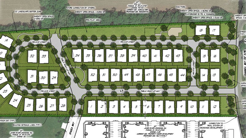
- The developers of The Crossings have proposed expanding the development into a 12.24-acre parcel to build 52 single-family homes. Courtesy | Isle of Wight County
After delaying the vote a month, Isle of Wight County supervisors have approved a proposed expansion of The Crossings development in Carrollton.
Construction of a residential phase, which will include up to 240 condominium units, broke ground last year at Carrollton and Brewer’s Neck boulevards, and an adjacent commercial phase has already been approved. Located behind the two approved phases is a 12.24-acre parcel, on which the developers plan to construct 52 single-family homes.
On June 2, the supervisors voted unanimously to approve the requested rezoning of that parcel from rural agricultural conservation to mixed use.
According to the submitted plans, the expansion would still utilize a condominium ownership structure and would include a dog park, playground and sidewalks that would connect to the proposed trail system in the two previously approved phases. The expansion would include access roads off Channell Way and a new road serving the two approved phases named Spadea Way, which would also eventually connect to a future phase of the South Harbor age-restricted community being built behind the 7-Eleven on Carrollton Boulevard.
Carrollton-area Supervisor William McCarty, who made the motion to approve the expansion, described the proposed access roads as “taking the pressure off of Channell Way.”
Currently, motorists turning left onto Carrollton Boulevard from Channell Way must frequently stop at the break in the highway’s median and wait for a gap in traffic. Once the expansion builds out, Channell Way motorists will have the option of taking one of the connector roads and accessing Carrollton Boulevard from Spadea Way at a signalized intersection instead.
The 12.24-acre parcel “is not a large footprint” and will eventually be surrounded by other developments in the county’s Newport Development Service District, McCarty added. Isle of Wight has three DSDs, which serve as geographic areas where the county hopes to attract developers with available or planned water and sewer infrastructure and road improvements.
The supervisors had previously tabled voting on the proposed expansion in May after questioning whether its roads, some of which will be private, would be wide enough to accommodate firefighting apparatus. According to the developers, the private roadways will be 29 feet wide in accordance with Virginia Department of Transportation standards for two-lane roads with on-street parking on both sides.
Per changes the supervisors enacted last year to Isle of Wight’s subdivision ordinance, aimed at stemming the creation of new private roads, the county’s code defines public streets as those serving three or more separate properties, and requires they be built to VDOT standards. According to Amy Ring, the county’s director of community development, private roads are still allowed in this case because the development is using a condominium ownership structure, in which the roads are deemed to be only serving one property.