Draining of Sunken Meadow pond temporary, officials say
Published 5:41 pm Thursday, June 1, 2023
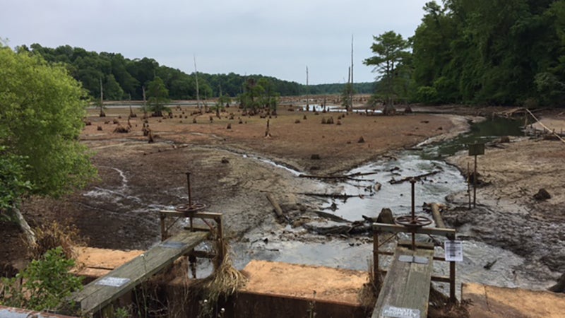
- A resident of Surry County submitted this photo of the work at the Sunken Meadow Pond near Claremont.
By Akilah Frye
Staff Writer
The temporary draining of a large pond near Claremont in Surry County is part of a topographic study and did not require a permit, state officials say.
Sunken Meadow Pond was drained into the James River so that Davey Mitigation could conduct a topographic study on the lake bed and determine the location of the natural boundary between tidal and non-tidal waters, according to the Virginia Department of Environmental Quality. The owners are interested in creating a stream and wetland mitigation bank to sell mitigation credits that offset losses of streams or wetlands pursuant to Virginia water protection laws. Existing survey data was inconclusive, so the pond’s water elevation was lowered to facilitate Light Detection and Ranging (LiDAR) measurements.
Sunken Meadow Pond is popular with locals and home to an enormous amount of wildlife, including fish, ducks, geese, otters and herons.
“The process for creating a stream and wetland mitigation bank at Sunken Meadow started with identifying a site that was historically a wetland and stream site before being impounded,” said Patrick Link, land operations manager at Davey Mitigation. “We then must complete multiple years of diligence (minimum of 2 years) to determine that converting the now open water system back to a functioning forested wetland and stream system is viable.”
The current impoundment is prohibiting anadromous and diadromous fish from accessing more than 20 miles of habitat upstream.
“Part of that diligence is to understand elevations and tidal influence on the system,” Link said. “That is what we are completing now. We will then fill the pond back up while we model and engineer the project.”
Irina Calos of the Virginia DEQ said the company has communicated with state and federal officials throughout the process.
“Although Davey Mitigation was not required to receive a permit from DEQ for work conducted thus far, they have been coordinating with the Virginia Department of Conservation and Recreation’s Dam Safety Program, the Virginia Department of Transportation, DEQ and the U.S. Army Corps of Engineers to ensure that any work is done safely and in compliance with applicable laws and regulations,” Calos said. “Water levels should return to normal within the next couple of weeks.”
Link said the project, if deemed viable, would go through an extensive permitting process.
“We will need to go through a process set up by the United States Army Corps of Engineers and the Virginia Department of Environmental Quality for approval of a mitigation bank, including how the bank would operate and design plans,” he said. “If the project is deemed viable, we would then remove the dam, plant, and seed native vegetation into the areas of suitable habitat and create or restore streams and wetlands where necessary.
“We then monitor and maintain the project for a minimum of 10 years making sure the streams and wetlands remain intact and healthy. Replanting and managing invasive species are just a couple of the things we will be responsible for during this period of time. When the project is deemed successful after that minimum of 10 years a long-term steward will take over managing the project in perpetuity. We fund a non-wasting endowment to make sure the project is successful forever.”
There would be multiple opportunities for public input, including public forums and a formal public notice and comment period for landowners to submit comments. There is currently no date set for the public notice.


